Sonntag, 11. August 2019
Meteorological report for July (Maribor)
beekids, 12:34h
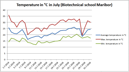
July was similar to June in terms of temperature. Fortunately, there were not many heat waves. High temperatures reduced precipitation throughout the month, occurring at regular intervals. Compared to July last year, temperatures were exactly the same, but there was twice as much precipitation as last July.
The difference between the highest (1th July) and the lowest (11th July) measured temperature in the month was as high as 23.8 °C.
The average monthly temperature was higher than the average of the period from 1981 to 2010, it was 21.65 °C and was 0.65 °C higher than the long-term average. The long-term average for July is 21.0 °C in Maribor. The average temperature was quite constant throughout the month, it was low only in the second week, even by five degrees. The difference between the average temperature of the coldest (8th July) and the warmest (25th July) day was as high as 9.85 °C. There were also great differences between night and day temperatures, ranging from 2.2 °C (28 th July) to 21.5 °C (1th July).
In July, the daily average temperature was thirteen times below the average of the period from 1981 to 2010 (21.0 °C). The maximum temperature for only one day did not exceed 20 °C, for twenty-five days it was above 25 °C, thereof for fourteen days it was above 30 °C. In July, we had one heat wave in Maribor (the temperature must be at least three days above 30 °C), which lasted for eight days. The lowest temperature in July was 12.0 °C, and the highest temperature was 35.8 °C. In the first seven months, the average temperature was 1.07 °C higher than the long-term average. According to the ARSO measurement method, which is official for the whole of Europe (measurements at 7, 14 and 21 hours) was 0.78 °C higher.
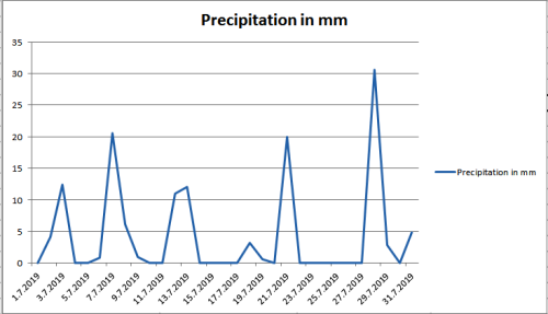
Precipitation data show that was much more precipitation in July than in June. In July fell 77 % more precipitation than in June, at the same time also more than the long-term average. The measuring device detected 130.2 mm of precipitation, which is higher as long as the long-term average (94 mm of precipitation). As compared to July 2018, there was twice as much precipitation. In the first seven months, 58 mm more precipitation fell than the long-term average. In the first seven months, fell 59.6 % of the long-term average precipitation. In comparison, last year only 3 mm less precipitation fell during this time.
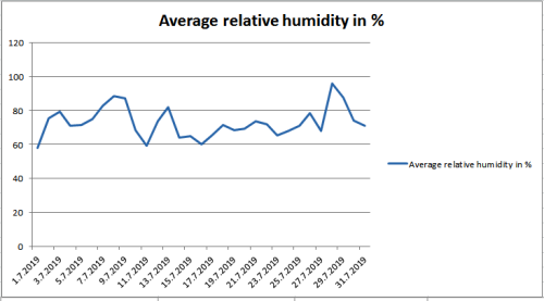
The average relative humidity in July was 72.93 %, which is slightly higher than in June and more than in July 2018 (68.72 %). Given much more precipitation, this was expected.
The difference between the highest (1th July) and the lowest (11th July) measured temperature in the month was as high as 23.8 °C.
The average monthly temperature was higher than the average of the period from 1981 to 2010, it was 21.65 °C and was 0.65 °C higher than the long-term average. The long-term average for July is 21.0 °C in Maribor. The average temperature was quite constant throughout the month, it was low only in the second week, even by five degrees. The difference between the average temperature of the coldest (8th July) and the warmest (25th July) day was as high as 9.85 °C. There were also great differences between night and day temperatures, ranging from 2.2 °C (28 th July) to 21.5 °C (1th July).
In July, the daily average temperature was thirteen times below the average of the period from 1981 to 2010 (21.0 °C). The maximum temperature for only one day did not exceed 20 °C, for twenty-five days it was above 25 °C, thereof for fourteen days it was above 30 °C. In July, we had one heat wave in Maribor (the temperature must be at least three days above 30 °C), which lasted for eight days. The lowest temperature in July was 12.0 °C, and the highest temperature was 35.8 °C. In the first seven months, the average temperature was 1.07 °C higher than the long-term average. According to the ARSO measurement method, which is official for the whole of Europe (measurements at 7, 14 and 21 hours) was 0.78 °C higher.

Precipitation data show that was much more precipitation in July than in June. In July fell 77 % more precipitation than in June, at the same time also more than the long-term average. The measuring device detected 130.2 mm of precipitation, which is higher as long as the long-term average (94 mm of precipitation). As compared to July 2018, there was twice as much precipitation. In the first seven months, 58 mm more precipitation fell than the long-term average. In the first seven months, fell 59.6 % of the long-term average precipitation. In comparison, last year only 3 mm less precipitation fell during this time.

The average relative humidity in July was 72.93 %, which is slightly higher than in June and more than in July 2018 (68.72 %). Given much more precipitation, this was expected.

... link (0 Kommentare) ... comment
Montag, 1. Juli 2019
Meteorological report for June (Maribor)
beekids, 16:51h
We could say that the weather turned around, when we compare June to May. Even in relation to last June, this time was completely reversed. Last year a lot of precipitation, this year's heat.
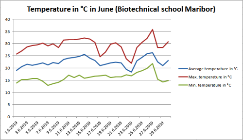
The difference between the highest (27th June) and the lowest (7th June) measured temperature in the month was as high as 22.9 °C.
The average monthly temperature was considerably higher than the average of the period from 1981 to 2010, it was 22.41 °C and it was 3.41 °C higher than the long-term average. The long-term average for June is 19,0 °C in Maribor. The average temperature was quite constant throughout the month. The difference between the average temperature of the coldest (23th June) and the warmest (27th June) day was as high as 7.99 °C. There were also great differences between night and day temperatures, even above 16 °C.
In June, the daily average temperature was only once below the average of the period from 1981 to 2010 (19.0 °C). The maximum temperature was above 20 °C all days, thereof twenty-five days above 25 °C, and thirteen days even above 30 °C. In June we had two heat waves in Maribor (the temperature must be at least three days above 30 °C). The first heat wave lasted for a whole week. The lowest temperature in June was 12.9 °C, and the highest temperature was 35.8 °C. In the first six months, the average temperature was 1.14 ° C higher than the long-term average. According to the ARSO measurement method, which is official for the whole of Europe (measurements at 7, 14 and 21 hours) was 0.87 °C higher.
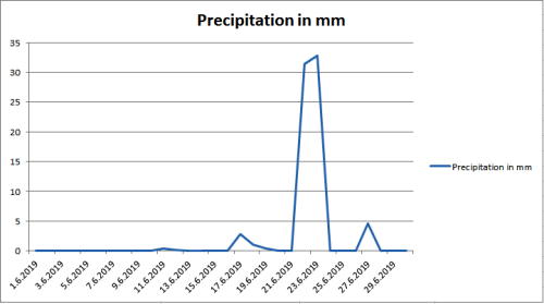
Precipitation data show that there was much less precipitation in June than in May. In June, half of the precipitation dropped, as in May, but also less than as the long-term average. The measuring device detected 73.6 mm of precipitation, which is much less as long as the long-term average (107 mm precipitation). In the first six months, 21.8 mm more precipitation fell than the long-term average.
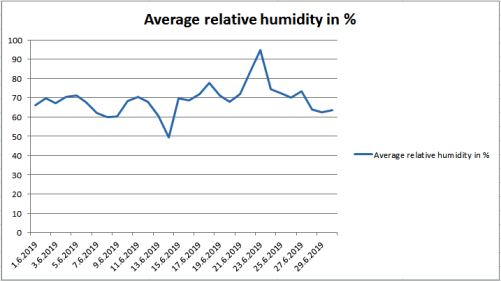
The average relative humidity in June was 68.98 %, which is less than in May and similar to 2018 (70.86 %). Given the less precipitation, this was expected.
The difference between the highest (27th June) and the lowest (7th June) measured temperature in the month was as high as 22.9 °C.
The average monthly temperature was considerably higher than the average of the period from 1981 to 2010, it was 22.41 °C and it was 3.41 °C higher than the long-term average. The long-term average for June is 19,0 °C in Maribor. The average temperature was quite constant throughout the month. The difference between the average temperature of the coldest (23th June) and the warmest (27th June) day was as high as 7.99 °C. There were also great differences between night and day temperatures, even above 16 °C.
In June, the daily average temperature was only once below the average of the period from 1981 to 2010 (19.0 °C). The maximum temperature was above 20 °C all days, thereof twenty-five days above 25 °C, and thirteen days even above 30 °C. In June we had two heat waves in Maribor (the temperature must be at least three days above 30 °C). The first heat wave lasted for a whole week. The lowest temperature in June was 12.9 °C, and the highest temperature was 35.8 °C. In the first six months, the average temperature was 1.14 ° C higher than the long-term average. According to the ARSO measurement method, which is official for the whole of Europe (measurements at 7, 14 and 21 hours) was 0.87 °C higher.

Precipitation data show that there was much less precipitation in June than in May. In June, half of the precipitation dropped, as in May, but also less than as the long-term average. The measuring device detected 73.6 mm of precipitation, which is much less as long as the long-term average (107 mm precipitation). In the first six months, 21.8 mm more precipitation fell than the long-term average.

The average relative humidity in June was 68.98 %, which is less than in May and similar to 2018 (70.86 %). Given the less precipitation, this was expected.

... link (0 Kommentare) ... comment
Meteorological report for May (Maribor)
beekids, 13:30h
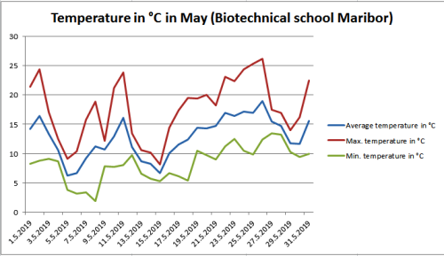
Was it May or April? This could be asked in terms of large amounts of precipitation. However, the temperatures were low compared to the long-term average. The difference between the highest (26th May) and the lowest (8th May) measured temperature in the month was 24.2 °C.
The average monthly temperature was lower than the average of the period from 1981 to 2010, it was 12.76 °C and it was 3.04 °C lower than the long-term average. The long-term average for May is 15.8 °C in Maribor.
In May, the daily average temperature was only seven times above the long-term average (15.8 °C). The maximum temperature was eleven times above 20 °C, thereof only two days above 25 °C. The lowest temperature in May was 1.9 °C and the highest temperature was 26.1 °C. In the first five months, the average temperature was 0.69 °C higher than the long-term average. According to ARSO, the measurement method, which is official for the whole of Europe (measurements at 7, 14 and 21 hours), was 0,43 °C higher.
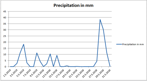
Precipitation during May was very rich with rain. In May, there were twice as much rainfall as the long-term average. The measuring device detected 158.4 mm of precipitation, which is more as long as the long-term average (83 mm precipitation). In the first five months, was 55.2 mm more precipitation than the long-term average.
The average relative humidity in May was 74.50 %, which is slightly more than in April. This was expected due to much more precipitation.
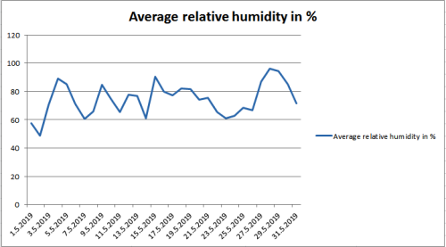
The average monthly temperature was lower than the average of the period from 1981 to 2010, it was 12.76 °C and it was 3.04 °C lower than the long-term average. The long-term average for May is 15.8 °C in Maribor.
In May, the daily average temperature was only seven times above the long-term average (15.8 °C). The maximum temperature was eleven times above 20 °C, thereof only two days above 25 °C. The lowest temperature in May was 1.9 °C and the highest temperature was 26.1 °C. In the first five months, the average temperature was 0.69 °C higher than the long-term average. According to ARSO, the measurement method, which is official for the whole of Europe (measurements at 7, 14 and 21 hours), was 0,43 °C higher.

Precipitation during May was very rich with rain. In May, there were twice as much rainfall as the long-term average. The measuring device detected 158.4 mm of precipitation, which is more as long as the long-term average (83 mm precipitation). In the first five months, was 55.2 mm more precipitation than the long-term average.

The average relative humidity in May was 74.50 %, which is slightly more than in April. This was expected due to much more precipitation.

... link (0 Kommentare) ... comment
Meteorological report for April (Maribor)
beekids, 13:14h
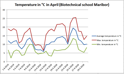
Finally, the normal month of this year, could be said, according to weather data. It was warm and more precipitation than in the previous three months. The difference between the highest (26th April) and the lowest (2nd April) measured temperature in the month was 23,3 °C.
The average monthly temperature was somewhat higher than the average of the period from 1981 to 2010, it was 11.41 °C and it was 0.61 °C higher than the long-term average. The long-term average for April is 10.8 °C in Maribor. However, if we compare only the average temperature of the last week of the month with the average period from 1981 to 2010, it was found that it was 3.2 °C higher.
In April, the average temperature was thirteen times below the average of the period from 1981 to 2010 (10.8 °C). The maximum temperature was seven days above 20 °C, thereof only two days above 25 °C. The lowest temperature in April was 2.2 °C and the highest temperature was 25.5 °C. In the first four months, the average temperature was 1.62 °C higher than the long-term average. According to the ARSO measurement method, which is official for the whole of Europe (measurements at 7, 14 and 21 hours), it was 1.36 °C higher.
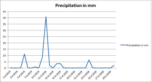
Precipitation data show that April was richer with precipitation. Precipitation during April was higher than average. The measuring device detected 79 mm precipitation, which is more than as long as the long-term average (60 mm precipitation). In the first four months was 20.2 mm less precipitation than the long-term average.
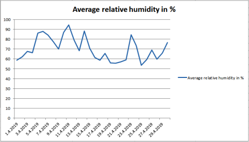
The average relative humidity in April was 70.10 %, which is slightly more than in March. Given the higher rainfall, this is expected.
The average monthly temperature was somewhat higher than the average of the period from 1981 to 2010, it was 11.41 °C and it was 0.61 °C higher than the long-term average. The long-term average for April is 10.8 °C in Maribor. However, if we compare only the average temperature of the last week of the month with the average period from 1981 to 2010, it was found that it was 3.2 °C higher.
In April, the average temperature was thirteen times below the average of the period from 1981 to 2010 (10.8 °C). The maximum temperature was seven days above 20 °C, thereof only two days above 25 °C. The lowest temperature in April was 2.2 °C and the highest temperature was 25.5 °C. In the first four months, the average temperature was 1.62 °C higher than the long-term average. According to the ARSO measurement method, which is official for the whole of Europe (measurements at 7, 14 and 21 hours), it was 1.36 °C higher.

Precipitation data show that April was richer with precipitation. Precipitation during April was higher than average. The measuring device detected 79 mm precipitation, which is more than as long as the long-term average (60 mm precipitation). In the first four months was 20.2 mm less precipitation than the long-term average.

The average relative humidity in April was 70.10 %, which is slightly more than in March. Given the higher rainfall, this is expected.

... link (0 Kommentare) ... comment
Meteorological report for March (Maribor)
beekids, 12:59h
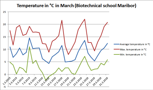
High temperatures continued in Maribor in March. There was also a noticeable fluctuation of temperatures, which was going on throughout the month. The difference between the highest (22nd March) and the lowest (12th March) measured temperature in the month was 24.4 °C, which is much less than the measured difference in March 2018 when it was as high as 36.1 °C.
The average monthly temperature was significantly higher than the average of the period from 1981 to 2010, it was 8,59 °C, and it was 2,59 °C higher than the long-term average. The long-term average for March is 6 °C in Maribor. By comparison, in March 2018, the average temperature was 5.24 ° C lower. In the first three months of this year, the temperatures are quite different from the previous year.
The minimum temperature was only two days below the freezing point. The lowest temperature in March was -2.4 °C and the highest temperature was 22 °C.
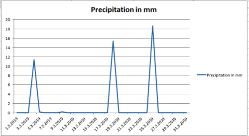
Precipitation data show that March was again below the average rainfall, as less precipitation fell than the long-standing average.
The measuring device detected 45.8 mm of precipitation, which is slightly less than the long-term average (57 mm precipitation).
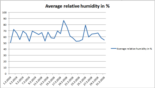
The average relative humidity in March was 63.4 %, which is not surprising given the smaller amount of precipitation.
The average monthly temperature was significantly higher than the average of the period from 1981 to 2010, it was 8,59 °C, and it was 2,59 °C higher than the long-term average. The long-term average for March is 6 °C in Maribor. By comparison, in March 2018, the average temperature was 5.24 ° C lower. In the first three months of this year, the temperatures are quite different from the previous year.
The minimum temperature was only two days below the freezing point. The lowest temperature in March was -2.4 °C and the highest temperature was 22 °C.

Precipitation data show that March was again below the average rainfall, as less precipitation fell than the long-standing average.
The measuring device detected 45.8 mm of precipitation, which is slightly less than the long-term average (57 mm precipitation).

The average relative humidity in March was 63.4 %, which is not surprising given the smaller amount of precipitation.

... link (0 Kommentare) ... comment
Freitag, 15. M�rz 2019
Weather report for 2018
beekids, 11:28h
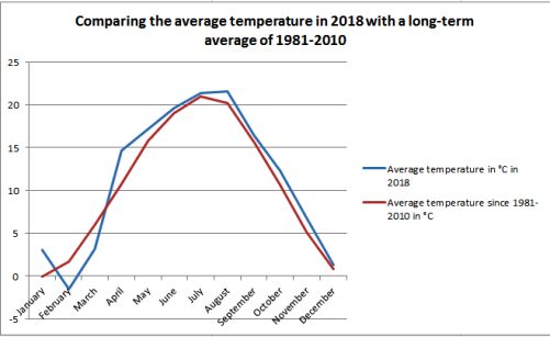
Here is the final weather report for 2018 (the estate of the Biotechnical School Maribor). You can see important monthly data and a total average for 2018. The report shows that the average temperature in 2018 was 11.34 °C or higher by 0.79 °C compared to the 30-year average. However, the year 2018 was not the warmest, it still belongs to 2000 and 2014, when the average temperature was 12 °C.
The highest temperature was 33.9 °C, which is far from the record temperature measured on the property, which was 40.6 °C (August 8th 2013). But the record mark (- 23 °C) approached the lowest temperature in 2018, which was - 20.2 °C.
In 2018 there were 27 days warmer than 30 °C, fortunately only five days were such that even the lowest daily temperature did not fall below 20 °C (tropical night).
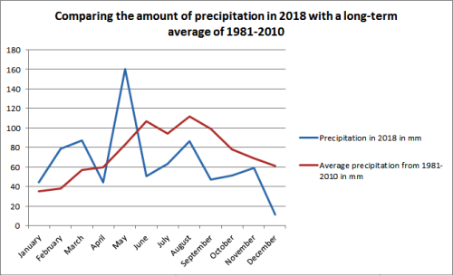
In the year 2018, precipitation was only 784.6 mm, which is much less than the 30-year average (893 mm). The highest precipitation was recorded in 1962 (1304 mm) and the lowest in 2011 (604 mm).
In 2018 we only had one very rainy day when 78.6 mm of precipitation fell (4. 5. 2018). Especially in the first half of the year, we felt that the rain was falling steadily (93 days of precipitation), but it should be emphasized that 31 days were of such occurrence as less than 1 mm precipitation fell. So we can say that it is often only a rosé, which does not greatly benefit the plants or can even harm them if the temperature is high enough (the possibility of mold and rust).
You can find more detailed information in the attachment.
weather_report_maribor2018 (pdf, 150 KB)
Comparison of average monthly temperatures in 2018 with the long-term average of the period 1981-2010.
Comparison of precipitation in 2018 with a long-term average of the period 1981-2010.
The highest temperature was 33.9 °C, which is far from the record temperature measured on the property, which was 40.6 °C (August 8th 2013). But the record mark (- 23 °C) approached the lowest temperature in 2018, which was - 20.2 °C.
In 2018 there were 27 days warmer than 30 °C, fortunately only five days were such that even the lowest daily temperature did not fall below 20 °C (tropical night).
In the year 2018, precipitation was only 784.6 mm, which is much less than the 30-year average (893 mm). The highest precipitation was recorded in 1962 (1304 mm) and the lowest in 2011 (604 mm).
In 2018 we only had one very rainy day when 78.6 mm of precipitation fell (4. 5. 2018). Especially in the first half of the year, we felt that the rain was falling steadily (93 days of precipitation), but it should be emphasized that 31 days were of such occurrence as less than 1 mm precipitation fell. So we can say that it is often only a rosé, which does not greatly benefit the plants or can even harm them if the temperature is high enough (the possibility of mold and rust).
You can find more detailed information in the attachment.
weather_report_maribor2018 (pdf, 150 KB)
Comparison of average monthly temperatures in 2018 with the long-term average of the period 1981-2010.

Comparison of precipitation in 2018 with a long-term average of the period 1981-2010.

... link (0 Kommentare) ... comment
Meteorological report for February (Maribor)
beekids, 10:35h
Are climate change really not happening? Weather conditions are changing rapidly, especially when compared to long-term measurements. This February was a real contradiction to last year's. February 2018 showed us that it is truly a winter month. This year, it's spring.
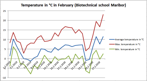
The difference between the highest (28th February) and the lowest (7th February) measured temperature in the month was as high as 31 °C. From this, we can understand, that we had cold nights and mornings and too high daily temperatures.
The average monthly temperature was much higher than the average of the period from 1981 to 2010, it was 4,7 °C, and it was 3 °C higher than the long-term average. By comparison, in February 2018, the average temperature was - 1.41 °C (6.11 °C lower). The long-term average for February is 1.7 °C in Maribor. If we compare only the average temperature of the second half of the month with the average period from 1981 to 2010, we can see that it was higher by 4.53 °C.
In February, the average temperature was only five times below the freezing point (0 °C). The maximum temperature did not reach even the freezing point. The minimum temperature was nine times above the freezing point. The lowest temperature in February was - 8 °C, and the highest temperature was 23 °C. Compared to February 2018, the lowest temperature was - 20.2 °C and the highest was 11.58 °C.
Precipitation data show that the trend of falling precipitation is still continuing. There was no snow fall at all, therefore drought is expected in March, especially in cereals (barley, wheat).
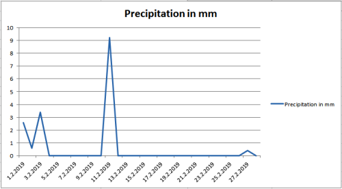
In February there was less precipitation than a long-term average. The measuring device detected only 16.2 mm of precipitation, and the long-term average is 38 mm precipitation. Most precipitation dropped in the first half of the month. In February 2018, dropped 78.6 mm of precipitation and 106.8 cm of snow.
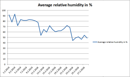
The average relative humidity in February was 67.85 %, which is even less than in January. In February 2018 it was as much as 86.42 %.
The difference between the highest (28th February) and the lowest (7th February) measured temperature in the month was as high as 31 °C. From this, we can understand, that we had cold nights and mornings and too high daily temperatures.
The average monthly temperature was much higher than the average of the period from 1981 to 2010, it was 4,7 °C, and it was 3 °C higher than the long-term average. By comparison, in February 2018, the average temperature was - 1.41 °C (6.11 °C lower). The long-term average for February is 1.7 °C in Maribor. If we compare only the average temperature of the second half of the month with the average period from 1981 to 2010, we can see that it was higher by 4.53 °C.
In February, the average temperature was only five times below the freezing point (0 °C). The maximum temperature did not reach even the freezing point. The minimum temperature was nine times above the freezing point. The lowest temperature in February was - 8 °C, and the highest temperature was 23 °C. Compared to February 2018, the lowest temperature was - 20.2 °C and the highest was 11.58 °C.

Precipitation data show that the trend of falling precipitation is still continuing. There was no snow fall at all, therefore drought is expected in March, especially in cereals (barley, wheat).
In February there was less precipitation than a long-term average. The measuring device detected only 16.2 mm of precipitation, and the long-term average is 38 mm precipitation. Most precipitation dropped in the first half of the month. In February 2018, dropped 78.6 mm of precipitation and 106.8 cm of snow.

The average relative humidity in February was 67.85 %, which is even less than in January. In February 2018 it was as much as 86.42 %.

... link (0 Kommentare) ... comment
Meteorological report for January (Maribor)
beekids, 09:27h
January is the central month of meteorological winter and is usually the coldest month of the year, which was not the case in January 2018, which was the third warmest January since the temperature has been measured in Slovenia. This year, January was more normal, although the temperatures were still too high.
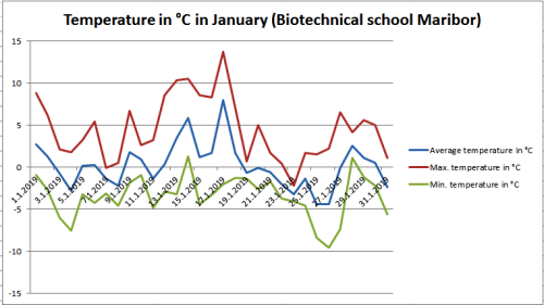
The difference between the highest (January 17) and the lowest (January 26) measured temperature in the month was 23.3 °C.
The average monthly temperature was higher than the average of the period from 1981 to 2010, it was 0.17 °C and it was 0.27 °C higher than the long-term average. The long-term average for January is - 0.1 °C in Maribor. For comparison, in January 2018, the average temperature was 2.87 °C.
The difference in average temperature between the coldest (January 26) and the warmest (January 17) day was 12.38 °C.
In January, the average temperature was fourteen times below the long-term average (- 0.1 °C). The maximum temperature was three days above 10 °C, and only two days below 0 °C. The lowest temperature in January was - 9.6 °C and the highest temperature was 13.7 °C.
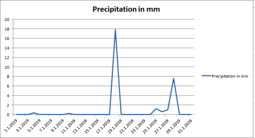
Precipitation data show that there was very little precipitation in January, which has been happening for more than half a year. The problem is that there were no snowfalls, which represent a stock of water for the spring months. There were seven rainy days, with 28.8 mm of precipitation, which is less as long as the long-term average (35 mm of precipitation). In January 2018, fell 44.4 mm of precipitation.
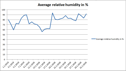
The average relative humidity in January was 77.22 %, which is less than in January 2018 (85.28%). Given the lower amount of precipitation this is normal. In January there was a significant fluctuation in air humidity, with only 55 % to 93 % of moisture.
The difference between the highest (January 17) and the lowest (January 26) measured temperature in the month was 23.3 °C.
The average monthly temperature was higher than the average of the period from 1981 to 2010, it was 0.17 °C and it was 0.27 °C higher than the long-term average. The long-term average for January is - 0.1 °C in Maribor. For comparison, in January 2018, the average temperature was 2.87 °C.
The difference in average temperature between the coldest (January 26) and the warmest (January 17) day was 12.38 °C.
In January, the average temperature was fourteen times below the long-term average (- 0.1 °C). The maximum temperature was three days above 10 °C, and only two days below 0 °C. The lowest temperature in January was - 9.6 °C and the highest temperature was 13.7 °C.

Precipitation data show that there was very little precipitation in January, which has been happening for more than half a year. The problem is that there were no snowfalls, which represent a stock of water for the spring months. There were seven rainy days, with 28.8 mm of precipitation, which is less as long as the long-term average (35 mm of precipitation). In January 2018, fell 44.4 mm of precipitation.

The average relative humidity in January was 77.22 %, which is less than in January 2018 (85.28%). Given the lower amount of precipitation this is normal. In January there was a significant fluctuation in air humidity, with only 55 % to 93 % of moisture.

... link (0 Kommentare) ... comment
Dienstag, 1. Januar 2019
Meteorological report for December (Maribor)
beekids, 11:59h
In December we had a weather that was too hot for this season. The average temperatures were very diverse at that time, for a few days we had average temperatures below zero, a few days above zero, and this was repeated all month. A drastic trend of falling rainfall continued.
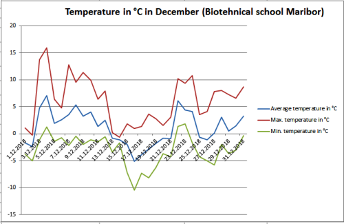
The difference between the highest (December 4) and the lowest (December 16) measured temperature in the month was as high as 26.4 °C. This is not such a big surprise, given the very high temperature fluctuations throughout the month.
The average monthly temperature was significantly higher than the average of the period from 1981 to 2010 – it was 1.09 °C, and it was 0.29 °C higher than the long-term average. The long-term average for December is 0.8 °C in Maribor. The average temperature fluctuated throughout the month. The difference between the average temperature of the coldest (December 16) and the warmest (December 4) day was 12.21 °C. The differences between night and day temperatures were reduced. The difference ranged from 1 to 15 °C, and on average the differences were greater than in November. In December the difference was 9 °C (In November 6 °C).
In December, the daily average temperature was fifteen times below the average of the period from 1981 to 2010 (0.8 °C). The maximum temperature was six days above 10 °C, one day above 15 °C, and only two days below 0 °C. The lowest temperature in December was -10.5 °C, and the highest temperature was 15.9 °C. In the last month, the average temperature dropped by 0.06 °C in relation to the long-term average.
Precipitation data show that there was very little precipitation in December, which has been happening for more than half a year. In December, only 19 % of the precipitation dropped, as is the long-standing average. The measuring device detected 11.6 mm of precipitation, which is much less as long as the long-term average (61 mm of precipitation).
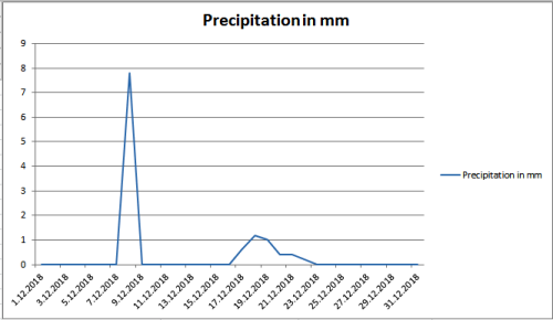
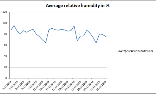
The average relative humidity in December was 81.98 %, which is less than in November. For December, there was a significant fluctuation in relative humidity (between 63 % to 95 %). Interestingly, only 88 % of moisture was in the air, on the only real rainy day of the month.
The difference between the highest (December 4) and the lowest (December 16) measured temperature in the month was as high as 26.4 °C. This is not such a big surprise, given the very high temperature fluctuations throughout the month.
The average monthly temperature was significantly higher than the average of the period from 1981 to 2010 – it was 1.09 °C, and it was 0.29 °C higher than the long-term average. The long-term average for December is 0.8 °C in Maribor. The average temperature fluctuated throughout the month. The difference between the average temperature of the coldest (December 16) and the warmest (December 4) day was 12.21 °C. The differences between night and day temperatures were reduced. The difference ranged from 1 to 15 °C, and on average the differences were greater than in November. In December the difference was 9 °C (In November 6 °C).
In December, the daily average temperature was fifteen times below the average of the period from 1981 to 2010 (0.8 °C). The maximum temperature was six days above 10 °C, one day above 15 °C, and only two days below 0 °C. The lowest temperature in December was -10.5 °C, and the highest temperature was 15.9 °C. In the last month, the average temperature dropped by 0.06 °C in relation to the long-term average.

Precipitation data show that there was very little precipitation in December, which has been happening for more than half a year. In December, only 19 % of the precipitation dropped, as is the long-standing average. The measuring device detected 11.6 mm of precipitation, which is much less as long as the long-term average (61 mm of precipitation).

The average relative humidity in December was 81.98 %, which is less than in November. For December, there was a significant fluctuation in relative humidity (between 63 % to 95 %). Interestingly, only 88 % of moisture was in the air, on the only real rainy day of the month.

... link (0 Kommentare) ... comment
Dienstag, 25. Dezember 2018
Meteorological report for November (Maribor)
beekids, 09:36h
In November, the warm autumn weather continued, which only faltered in the second half of the month. The average temperatures were very diverse at that time. In the last part of the month, temperatures dropped significantly on average. The reducing trend of the amount of precipitation was continued.
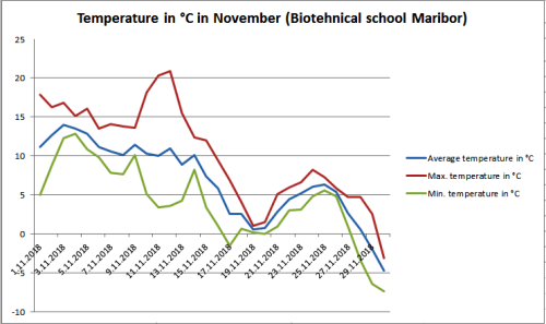
The difference between the highest (November 12) and the lowest (November 30) measured temperature in the month was as high as 28.2 °C. This is not such a big surprise, given the very high temperatures in the first part of the month and low in the last part of the month.
The average monthly temperature was also significantly higher than the average of the period from 1981 to 2010 – it was 6.81 °C, and it was 1.71 °C higher than the long-term average. The long-term average for November is 5.1 °C in Maribor. The average temperature was very high in the first half of the month, but fairly constant. In the second half of the month the average temperature dropped by as much as 10 °C. The difference between the average temperature of the coldest (November 30) and the warmest (November 3) day was 18.62 °C. The differences between night and day temperatures were reduced. The difference ranged from 1 to 17 °C, and on average only about 6 °C.
In November, the daily average temperature was only ten times below the average of the period from 1981 to 2010 (5.1 °C). The maximum temperature was nine days above 15 °C, two days above 20 °C, and only 7 days below 5 °C. The lowest temperature in November was -7.3 °C, and the highest temperature was 20.9 °C. In the first eleven months, the average temperature was 1.08 °C higher than the long-term average. In the last month, the average temperature increased by 0.06 °C in relation to the long-term average.
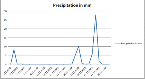
Precipitation data show that there was very little precipitation in November, what is happening in the last half of the year. In November, 86 % of the precipitation dropped, as is the long-standing average. The measuring device detected 59.4 mm of precipitation, which is much less as long as the long-term average (69 mm of precipitation). In the first eleven months, 59 mm less precipitation fell than the long-term average. In the first eleven months we recorded as much as 146 precipitation days or 43.7 % days.
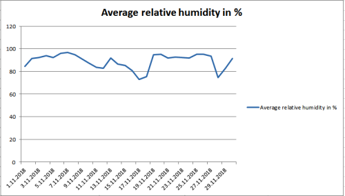
The average relative humidity in November was 89.05 %, which is much more than in October. According to cold nights and more moisture in the air during the day, this was expected.
The difference between the highest (November 12) and the lowest (November 30) measured temperature in the month was as high as 28.2 °C. This is not such a big surprise, given the very high temperatures in the first part of the month and low in the last part of the month.
The average monthly temperature was also significantly higher than the average of the period from 1981 to 2010 – it was 6.81 °C, and it was 1.71 °C higher than the long-term average. The long-term average for November is 5.1 °C in Maribor. The average temperature was very high in the first half of the month, but fairly constant. In the second half of the month the average temperature dropped by as much as 10 °C. The difference between the average temperature of the coldest (November 30) and the warmest (November 3) day was 18.62 °C. The differences between night and day temperatures were reduced. The difference ranged from 1 to 17 °C, and on average only about 6 °C.
In November, the daily average temperature was only ten times below the average of the period from 1981 to 2010 (5.1 °C). The maximum temperature was nine days above 15 °C, two days above 20 °C, and only 7 days below 5 °C. The lowest temperature in November was -7.3 °C, and the highest temperature was 20.9 °C. In the first eleven months, the average temperature was 1.08 °C higher than the long-term average. In the last month, the average temperature increased by 0.06 °C in relation to the long-term average.

Precipitation data show that there was very little precipitation in November, what is happening in the last half of the year. In November, 86 % of the precipitation dropped, as is the long-standing average. The measuring device detected 59.4 mm of precipitation, which is much less as long as the long-term average (69 mm of precipitation). In the first eleven months, 59 mm less precipitation fell than the long-term average. In the first eleven months we recorded as much as 146 precipitation days or 43.7 % days.

The average relative humidity in November was 89.05 %, which is much more than in October. According to cold nights and more moisture in the air during the day, this was expected.

... link (0 Kommentare) ... comment
... nächste Seite