Samstag, 19. Mai 2018
Meteorological report for April (Maribor)
beekids, 20:40h
Is April spring or summer month? This question arises us because of high temperature in the second half of the month. The difference between the highest (23th April) and the lowest (2nd April) measured temperature in the month was as high as 28.8 °C.
The average monthly temperature was also significantly higher than the average of the period from 1981 to 2010 – it was 15,14 °C, and it was 4,34 °C higher than the long-term average. The long-term average for April is 10.8 °C in Maribor. However, if we compare the average temperature of the second half of the month with the average of the period from 1981 to 2010, it was found that it was higher by as much as 13.77 °C.
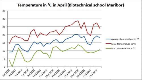
In April, the daily average temperature was only four times below the average of the period from 1981 to 2010 (10.8 °C). The maximum temperature was twenty times above 20 °C, thereof eight days above 25 °C. The lowest temperature in April was 0 °C, and the highest temperature was 28.8 °C. In the first four months, the average temperature was 0.39 °C higher than the long-term average.
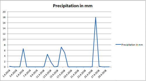
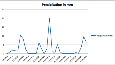
Precipitation during April was less than average. The measuring device detected 44 mm of precipitation, which is less than as long as the long-term average (60 mm of precipitation). In the first four months, was 64.4 mm more precipitation than the long-term average.
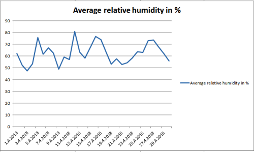
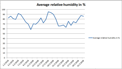
The average relative humidity in April was 62.22 %, which is 15.38 % less as in March. This was expected due to less precipitation.
The average monthly temperature was also significantly higher than the average of the period from 1981 to 2010 – it was 15,14 °C, and it was 4,34 °C higher than the long-term average. The long-term average for April is 10.8 °C in Maribor. However, if we compare the average temperature of the second half of the month with the average of the period from 1981 to 2010, it was found that it was higher by as much as 13.77 °C.
In April, the daily average temperature was only four times below the average of the period from 1981 to 2010 (10.8 °C). The maximum temperature was twenty times above 20 °C, thereof eight days above 25 °C. The lowest temperature in April was 0 °C, and the highest temperature was 28.8 °C. In the first four months, the average temperature was 0.39 °C higher than the long-term average.
Precipitation during April was less than average. The measuring device detected 44 mm of precipitation, which is less than as long as the long-term average (60 mm of precipitation). In the first four months, was 64.4 mm more precipitation than the long-term average.
The average relative humidity in April was 62.22 %, which is 15.38 % less as in March. This was expected due to less precipitation.
... link (0 Kommentare) ... comment
Freitag, 27. April 2018
Meteorological report for March (Maribor)
beekids, 22:54h
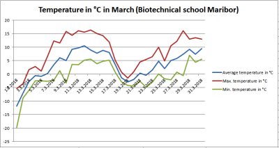
Winter continued into March. The first and the third week were especially cold. The difference between the highest (13th March) and the lowest (1st March) measured temperature in the month was as high as 36.1 °C.
The average monthly temperature was also significantly lower than the average of the period from 1981 to 2010, it was 3,35 °C, and it was 2,65 °C lower than the long-term average. The long-term average for March is 6 °C in Maribor. However, if we compare only the average temperature of the first week with the average of the period from 1981 to 2010, it was found that it was lower by as much as 8.78 °C.
In March, the average temperature was nine times below the freezing point (0 °C). The minimum daily temperature was seventeen days below the freezing point. The lowest temperature in March was - 19.8 °C, and the highest temperature was 16.3 °C.
Precipitation data show that March was rich in precipitation. The first part of the month was a lot of snow, while in the second part there was rainy.
According to the data of the meteorological station in the center of Maribor, there was 54.9 cm of snowfall in March.
Precipitation during March was above average. The measuring device detected 87.4 mm of precipitation, which is much more as long as the long-term average (57 mm of precipitation).
The average relative humidity in March was 77.6 %, which is 9 % less as in February.
... link (0 Kommentare) ... comment
Freitag, 20. April 2018
HH weather report march 2018 Part 3
meadowkids.eu, 11:31h
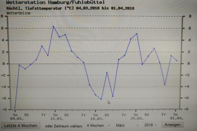
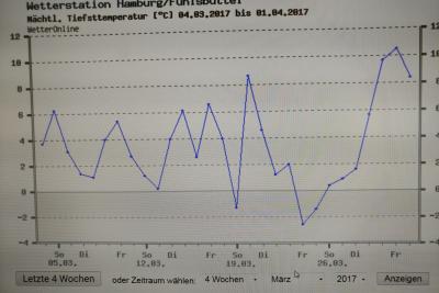
The low temperature graphs are also interseting. Especially the Year 2017 show us high temperatures in the night. That intersting because of the lot of rain.
This march 2018 was with coldest nights since a lot of years and colder than 1997. In 1997 there was one night by minus 4 degree. In 2018 we had one night by -4, two nights nearby -6 and one night much colder. And also three nights under zero to -1 degree.
1997 we had only four nights nearby -2 degrees. In the other years the temperature nearby zero and higher.
https://www.wetteronline.de/wetterdaten/hamburg?pcid=pc_rueckblick_data&gid=10147&pid=p_rueckblick_diagram&sid=StationHistory&iid=10147&metparaid=TNLD&period=4&month=03&year=2018
https://www.wetteronline.de/wetterdaten/hamburg?pcid=pc_rueckblick_data&gid=10147&pid=p_rueckblick_diagram&sid=StationHistory&iid=10147&metparaid=TNLD&period=4&month=03&year=2017
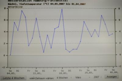
https://www.wetteronline.de/wetterdaten/hamburg?pcid=pc_rueckblick_data&gid=10147&pid=p_rueckblick_diagram&sid=StationHistory&iid=10147&metparaid=TNLD&period=4&month=03&year=2007
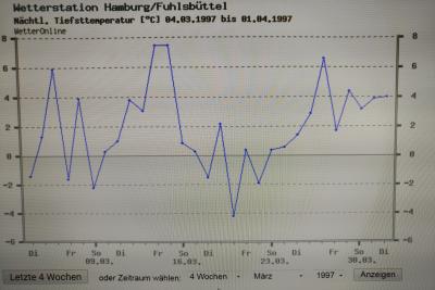
https://www.wetteronline.de/wetterdaten/hamburg?pcid=pc_rueckblick_data&gid=10147&pid=p_rueckblick_diagram&sid=StationHistory&iid=10147&metparaid=TNLD&period=4&month=03&year=1997
In this mounth isn`t a so clearly tendenz about Earthwarming discernible.
This march 2018 was with coldest nights since a lot of years and colder than 1997. In 1997 there was one night by minus 4 degree. In 2018 we had one night by -4, two nights nearby -6 and one night much colder. And also three nights under zero to -1 degree.
1997 we had only four nights nearby -2 degrees. In the other years the temperature nearby zero and higher.
https://www.wetteronline.de/wetterdaten/hamburg?pcid=pc_rueckblick_data&gid=10147&pid=p_rueckblick_diagram&sid=StationHistory&iid=10147&metparaid=TNLD&period=4&month=03&year=2018
https://www.wetteronline.de/wetterdaten/hamburg?pcid=pc_rueckblick_data&gid=10147&pid=p_rueckblick_diagram&sid=StationHistory&iid=10147&metparaid=TNLD&period=4&month=03&year=2017
https://www.wetteronline.de/wetterdaten/hamburg?pcid=pc_rueckblick_data&gid=10147&pid=p_rueckblick_diagram&sid=StationHistory&iid=10147&metparaid=TNLD&period=4&month=03&year=2007
https://www.wetteronline.de/wetterdaten/hamburg?pcid=pc_rueckblick_data&gid=10147&pid=p_rueckblick_diagram&sid=StationHistory&iid=10147&metparaid=TNLD&period=4&month=03&year=1997
In this mounth isn`t a so clearly tendenz about Earthwarming discernible.
... link (0 Kommentare) ... comment
HH weather report march 2018 Part 2
meadowkids.eu, 11:06h
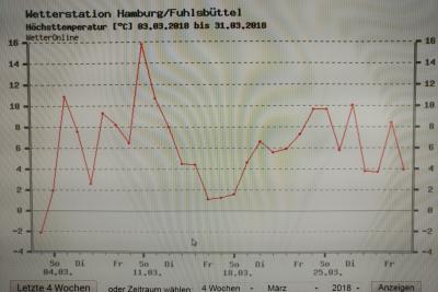
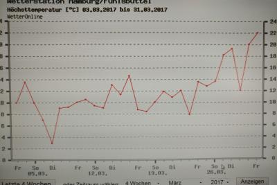
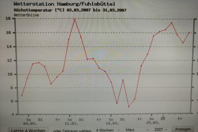
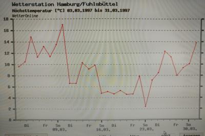
In the following temperature graphs from the Years 2018, 2017, 2007 and 1997 we see that the high temperatures lie nearby the same graph curves.
https://www.wetteronline.de/wetterdaten/hamburg?pcid=pc_rueckblick_data&gid=10147&pid=p_rueckblick_diagram&sid=StationHistory&iid=10147&metparaid=TXLD&period=4&month=03&year=2018
https://www.wetteronline.de/wetterdaten/hamburg?pcid=pc_rueckblick_data&gid=10147&pid=p_rueckblick_diagram&sid=StationHistory&iid=10147&metparaid=TXLD&period=4&month=03&year=2017
https://www.wetteronline.de/wetterdaten/hamburg?pcid=pc_rueckblick_data&gid=10147&pid=p_rueckblick_diagram&sid=StationHistory&iid=10147&metparaid=TXLD&period=4&month=03&year=2007
https://www.wetteronline.de/wetterdaten/hamburg?pcid=pc_rueckblick_data&gid=10147&pid=p_rueckblick_diagram&sid=StationHistory&iid=10147&metparaid=TXLD&period=4&month=03&year=1997
In the same way we can see that the year 2017 was special. We have high rise temperature beside a certain amount of hail in comparsion with the other years.
... link (0 Kommentare) ... comment
Donnerstag, 19. April 2018
HH weather report March 2018 Part 1
meadowkids.eu, 13:38h
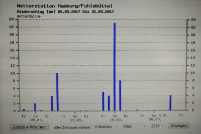
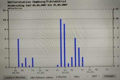
In march of this Year we had less certain amount of rain then in the year before.

14 days with rain and snow-rain.
https://www.wetteronline.de/wetterdaten/hamburg?pcid=pc_rueckblick_data&gid=10147&pid=p_rueckblick_diagram&sid=StationHistory&iid=10147&metparaid=RR24&period=4&month=03&year=2018
13 days of rain.
https://www.wetteronline.de/wetterdaten/hamburg?pcid=pc_rueckblick_data&gid=10147&pid=p_rueckblick_diagram&sid=StationHistory&iid=10147&metparaid=RR24&period=4&month=03&year=2017
13 days of rain.
https://www.wetteronline.de/wetterdaten/hamburg?pcid=pc_rueckblick_data&gid=10147&pid=p_rueckblick_diagram&sid=StationHistory&iid=10147&metparaid=RR24&period=4&month=03&year=2007
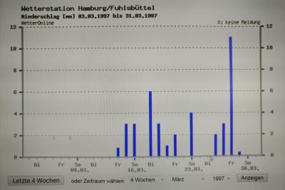
12 days of hail.
https://www.wetteronline.de/wetterdaten/hamburg?pcid=pc_rueckblick_data&gid=10147&pid=p_rueckblick_diagram&sid=StationHistory&iid=10147&metparaid=RR24&period=4&month=03&year=1997
By the diagrams you can`t see any extremly differents but you can see just as our older diagrams about the last year (2017), it was extremly wet.
14 days with rain and snow-rain.
https://www.wetteronline.de/wetterdaten/hamburg?pcid=pc_rueckblick_data&gid=10147&pid=p_rueckblick_diagram&sid=StationHistory&iid=10147&metparaid=RR24&period=4&month=03&year=2018
13 days of rain.
https://www.wetteronline.de/wetterdaten/hamburg?pcid=pc_rueckblick_data&gid=10147&pid=p_rueckblick_diagram&sid=StationHistory&iid=10147&metparaid=RR24&period=4&month=03&year=2017
13 days of rain.
https://www.wetteronline.de/wetterdaten/hamburg?pcid=pc_rueckblick_data&gid=10147&pid=p_rueckblick_diagram&sid=StationHistory&iid=10147&metparaid=RR24&period=4&month=03&year=2007
12 days of hail.
https://www.wetteronline.de/wetterdaten/hamburg?pcid=pc_rueckblick_data&gid=10147&pid=p_rueckblick_diagram&sid=StationHistory&iid=10147&metparaid=RR24&period=4&month=03&year=1997
By the diagrams you can`t see any extremly differents but you can see just as our older diagrams about the last year (2017), it was extremly wet.
... link (0 Kommentare) ... comment
Freitag, 2. M�rz 2018
Weather data Hamburg - February 2018
meadowkids.eu, 11:27h
In Hamburg we have the same weather trend like Maribor has. The February is the coldest month of the year with high temperature fluctuation. Over the years we can see, that also some days in Hamburg were really cold. If we compare the years 2018 and 2008, the temperatures are raising higher.


https://www.wetteronline.de/wetterdaten/hamburg?pcid=pc_rueckblick_data&gid=10147&pid=p_rueckblick_diagram&sid=StationHistory&iid=10147&metparaid=TNLD&period=4&month=02&year=2018


https://www.wetteronline.de/wetterdaten/hamburg?pcid=pc_rueckblick_data&gid=10147&pid=p_rueckblick_diagram&sid=StationHistory&iid=10147&metparaid=TNLD&period=4&month=02&year=2008
10 years ago the lowest temperature was -7 Degrees. The lowest temperature this year was -13 degrees.
In the year 1998 was one day with -11 degrees and in the year 1988 around -4 degrees.
If we go more years back, we would find one night with -17 degree in the 1978.
This February 2018 was the coldest winter month since the past 40 years. In this month the temperatures vary from between -10 to 0, up to between - 6 and +2 degrees.
In the last 20 year we had the most days with the temperature around 0 degree. T

https://www.wetteronline.de/wetterdaten/hamburg?pcid=pc_rueckblick_data&gid=10147&pid=p_rueckblick_diagram&sid=StationHistory&iid=10147&metparaid=TNLD&period=4&month=02&year=2018

https://www.wetteronline.de/wetterdaten/hamburg?pcid=pc_rueckblick_data&gid=10147&pid=p_rueckblick_diagram&sid=StationHistory&iid=10147&metparaid=TNLD&period=4&month=02&year=2008
In the last year we had almost the same rainy days, comparing to the years before, but we can see that the trend is going down. In the February 2008 we had one day with over 14 mm of rain - in the February 2018 we had only one day with 4 mm per square meter.
In the year 1998 we had a day with 8 mm and in the February 1978 we had max 4 mm/square meter.
In the year 1978 were 16 rainy days and in the year 1988 there were 24 days. The amount of days follow the lower level of hail. Nevertheless this February was the coldest February since 1978.
We can see that the trend of temperature is raising over the months and the amount of water/square meter is going down.
To sum up, we can see, that this month was the driest since 2017.
https://www.wetteronline.de/wetterdaten/hamburg?pcid=pc_rueckblick_data&gid=10147&pid=p_rueckblick_diagram&sid=StationHistory&iid=10147&metparaid=TNLD&period=4&month=02&year=2018
https://www.wetteronline.de/wetterdaten/hamburg?pcid=pc_rueckblick_data&gid=10147&pid=p_rueckblick_diagram&sid=StationHistory&iid=10147&metparaid=TNLD&period=4&month=02&year=2008
10 years ago the lowest temperature was -7 Degrees. The lowest temperature this year was -13 degrees.
In the year 1998 was one day with -11 degrees and in the year 1988 around -4 degrees.
If we go more years back, we would find one night with -17 degree in the 1978.
This February 2018 was the coldest winter month since the past 40 years. In this month the temperatures vary from between -10 to 0, up to between - 6 and +2 degrees.
In the last 20 year we had the most days with the temperature around 0 degree. T
https://www.wetteronline.de/wetterdaten/hamburg?pcid=pc_rueckblick_data&gid=10147&pid=p_rueckblick_diagram&sid=StationHistory&iid=10147&metparaid=TNLD&period=4&month=02&year=2018
https://www.wetteronline.de/wetterdaten/hamburg?pcid=pc_rueckblick_data&gid=10147&pid=p_rueckblick_diagram&sid=StationHistory&iid=10147&metparaid=TNLD&period=4&month=02&year=2008
In the last year we had almost the same rainy days, comparing to the years before, but we can see that the trend is going down. In the February 2008 we had one day with over 14 mm of rain - in the February 2018 we had only one day with 4 mm per square meter.
In the year 1998 we had a day with 8 mm and in the February 1978 we had max 4 mm/square meter.
In the year 1978 were 16 rainy days and in the year 1988 there were 24 days. The amount of days follow the lower level of hail. Nevertheless this February was the coldest February since 1978.
We can see that the trend of temperature is raising over the months and the amount of water/square meter is going down.
To sum up, we can see, that this month was the driest since 2017.
... link (0 Kommentare) ... comment
Donnerstag, 1. M�rz 2018
Meteorological report for February (Maribor)
beekids, 23:31h
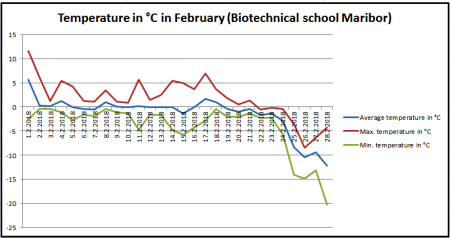
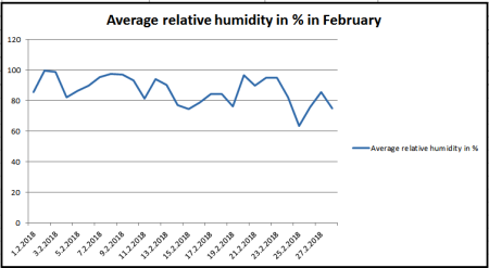
Although it is commonly considered that January is the coldest month of the year, this was not the case this year as February was much colder. With the exception of 1st February, which was nearer the temperature in January, the other days were cooler than the long-standing average. The difference between the highest (1st February) and the lowest (28th February) measured temperature in the month was as high as 31.78 °C. Last week in February, it was the coldest in the last thirty years.
The average monthly temperature was also significantly lower than the average of the period from 1981 to 2010, it was - 1,41 °C, and it was 3,11 °C lower than the long-term average. The long-term average for February is 1.7 °C in Maribor. However, if we compare only the average temperature of the last week with the average of the period from 1981 to 2010, it was found that it was lower by as much as 8.28 °C.
In February, the average temperature was nine times above the freezing point (0 °C). From 22nd to 28th February the maximum temperature did not exceed 0 °C. The minimum daily temperature was below the freezing point. The lowest temperature in February was - 20.2 °C, and the highest temperature was 11.58 °C.
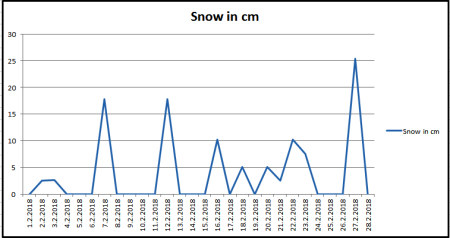
Precipitation data show that February was rich in precipitation. The first part of the month was rainy, while in the second part there was a lot of snow, which the measuring device did not detect. We can say that the precipitation was much higher than the graph shows. Precipitation during February was above average. The measuring device detected 78.6 mm of precipitation, which is about twice as long as the long-term average (38 mm of precipitation). The meteorological station in the center of Maribor detected 121 mm of precipitation. Most precipitation fell in the first half of the month.
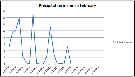
According to the data of the meteorological station in the center of Maribor, there was 106.8 cm of snowfall in February.
The average relative humidity in February was 86.42 %, which is approximately the same as in January.
The average monthly temperature was also significantly lower than the average of the period from 1981 to 2010, it was - 1,41 °C, and it was 3,11 °C lower than the long-term average. The long-term average for February is 1.7 °C in Maribor. However, if we compare only the average temperature of the last week with the average of the period from 1981 to 2010, it was found that it was lower by as much as 8.28 °C.
In February, the average temperature was nine times above the freezing point (0 °C). From 22nd to 28th February the maximum temperature did not exceed 0 °C. The minimum daily temperature was below the freezing point. The lowest temperature in February was - 20.2 °C, and the highest temperature was 11.58 °C.
Precipitation data show that February was rich in precipitation. The first part of the month was rainy, while in the second part there was a lot of snow, which the measuring device did not detect. We can say that the precipitation was much higher than the graph shows. Precipitation during February was above average. The measuring device detected 78.6 mm of precipitation, which is about twice as long as the long-term average (38 mm of precipitation). The meteorological station in the center of Maribor detected 121 mm of precipitation. Most precipitation fell in the first half of the month.
According to the data of the meteorological station in the center of Maribor, there was 106.8 cm of snowfall in February.
The average relative humidity in February was 86.42 %, which is approximately the same as in January.
... link (0 Kommentare) ... comment
Mittwoch, 28. Februar 2018
Weather data from the January 2018 in Hamburg-Rissen
meadowkids.eu, 14:27h
The weather data include all Hamburg districts, and also Rissen. The dates are collected in Hamburg, district Fuhlsbüttel.
We´re planing to build our own weather station, but the software is tricky and gave us a lot complications, that is why, we can only use the data from the weather station in Fuhlsbüttel.
Next graphic show us the data of temperature from January.
The first highest peak follows from the lowest peaks oft the temperature.


https://www.wetteronline.de/wetterdaten/hamburg?pcid=pc_rueckblick_data&gid=10147&pid=p_rueckblick_diagram&sid=StationHistory&iid=10147&month=01&year=2018&period=4&metparaid=RR24
The last graphic shows the peaks of rain in millimetre per square meter.

https://www.wetteronline.de/wetterdaten/hamburg?pcid=pc_rueckblick_data&gid=10147&pid=p_rueckblick_diagram&sid=StationHistory&iid=10147&month=01&year=2018&period=4&metparaid=RR24
If we look at the temperatures, we can see that with the low temperatures also came less rain.
The highest peaks of temperature, compare to January 2018, are 14 degree, in January 2008 are 12 degrees and in 1998 are 13 degrees. The temperature are from year to year raising. The highest temperature in 1998 is on most of the days around 0 degree or bellow it. In the following years the temperatures are going higher.

https://www.wetteronline.de/wetterdaten/hamburg?pcid=pc_rueckblick_data&gid=10147&pid=p_rueckblick_diagram&sid=StationHistory&iid=10147&metparaid=RR24&period=4&month=01&year=2008

https://www.wetteronline.de/wetterdaten/hamburg?pcid=pc_rueckblick_data&gid=10147&pid=p_rueckblick_diagram&sid=StationHistory&iid=10147&metparaid=RR24&period=4&month=01&year=2008
If you look at the night temperature you will see that in January 2018 they lying between + 8 an -6 degree, in January 2008 between +8 and -4 degree an in January +6,5 and -11,5 degree. In the last 20 years the diverenz between the day and night temperature the high degrees take away from the lower degrees. The monthly shape of temperature graded up to 1,5 degree an the lowest by 5,5 degree.

https://www.wetteronline.de/wetterdaten/hamburg?pcid=pc_rueckblick_data&gid=10147&pid=p_rueckblick_diagram&sid=StationHistory&iid=10147&metparaid=RR24&period=4&month=01&year=2008

https://www.wetteronline.de/wetterdaten/hamburg?pcid=pc_rueckblick_data&gid=10147&pid=p_rueckblick_diagram&sid=StationHistory&iid=10147&metparaid=RR24&period=4&month=01&year=1998

https://www.wetteronline.de/wetterdaten/hamburg?pcid=pc_rueckblick_data&gid=10147&pid=p_rueckblick_diagram&sid=StationHistory&iid=10147&metparaid=RR24&period=4&month=01&year=1998

https://www.wetteronline.de/wetterdaten/hamburg?pcid=pc_rueckblick_data&gid=10147&pid=p_rueckblick_diagram&sid=StationHistory&iid=10147&metparaid=RR24&period=4&month=01&year=1998
The precipitation show us only small differents. all years have compact a couple of day with precipitations. Ther e is a different between on which days. In the last ten year we get two more days with rain in January. The day with a high level of rain ar between 19 mm per squaremeter and 27mm. Possibly intersting is taht later days in month the precipitation get higher.
Shurely is that it`s was rain because the temperature are higher. Also are the temperature lower there are less decipitations.
We´re planing to build our own weather station, but the software is tricky and gave us a lot complications, that is why, we can only use the data from the weather station in Fuhlsbüttel.
Next graphic show us the data of temperature from January.
The first highest peak follows from the lowest peaks oft the temperature.
https://www.wetteronline.de/wetterdaten/hamburg?pcid=pc_rueckblick_data&gid=10147&pid=p_rueckblick_diagram&sid=StationHistory&iid=10147&month=01&year=2018&period=4&metparaid=RR24
The last graphic shows the peaks of rain in millimetre per square meter.
https://www.wetteronline.de/wetterdaten/hamburg?pcid=pc_rueckblick_data&gid=10147&pid=p_rueckblick_diagram&sid=StationHistory&iid=10147&month=01&year=2018&period=4&metparaid=RR24
If we look at the temperatures, we can see that with the low temperatures also came less rain.
The highest peaks of temperature, compare to January 2018, are 14 degree, in January 2008 are 12 degrees and in 1998 are 13 degrees. The temperature are from year to year raising. The highest temperature in 1998 is on most of the days around 0 degree or bellow it. In the following years the temperatures are going higher.
https://www.wetteronline.de/wetterdaten/hamburg?pcid=pc_rueckblick_data&gid=10147&pid=p_rueckblick_diagram&sid=StationHistory&iid=10147&metparaid=RR24&period=4&month=01&year=2008
https://www.wetteronline.de/wetterdaten/hamburg?pcid=pc_rueckblick_data&gid=10147&pid=p_rueckblick_diagram&sid=StationHistory&iid=10147&metparaid=RR24&period=4&month=01&year=2008
If you look at the night temperature you will see that in January 2018 they lying between + 8 an -6 degree, in January 2008 between +8 and -4 degree an in January +6,5 and -11,5 degree. In the last 20 years the diverenz between the day and night temperature the high degrees take away from the lower degrees. The monthly shape of temperature graded up to 1,5 degree an the lowest by 5,5 degree.
https://www.wetteronline.de/wetterdaten/hamburg?pcid=pc_rueckblick_data&gid=10147&pid=p_rueckblick_diagram&sid=StationHistory&iid=10147&metparaid=RR24&period=4&month=01&year=2008
https://www.wetteronline.de/wetterdaten/hamburg?pcid=pc_rueckblick_data&gid=10147&pid=p_rueckblick_diagram&sid=StationHistory&iid=10147&metparaid=RR24&period=4&month=01&year=1998
https://www.wetteronline.de/wetterdaten/hamburg?pcid=pc_rueckblick_data&gid=10147&pid=p_rueckblick_diagram&sid=StationHistory&iid=10147&metparaid=RR24&period=4&month=01&year=1998
https://www.wetteronline.de/wetterdaten/hamburg?pcid=pc_rueckblick_data&gid=10147&pid=p_rueckblick_diagram&sid=StationHistory&iid=10147&metparaid=RR24&period=4&month=01&year=1998
The precipitation show us only small differents. all years have compact a couple of day with precipitations. Ther e is a different between on which days. In the last ten year we get two more days with rain in January. The day with a high level of rain ar between 19 mm per squaremeter and 27mm. Possibly intersting is taht later days in month the precipitation get higher.
Shurely is that it`s was rain because the temperature are higher. Also are the temperature lower there are less decipitations.
... link (0 Kommentare) ... comment
Montag, 26. Februar 2018
Meteorological report for January
beekids, 18:37h
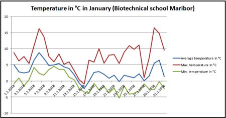
January is the central month of meteorological winter and is usually the coldest month of the year, which was not the case in January 2018, which was the third warmest January since the temperature has been measured in Slovenia. The situation in Maribor was the same, the maximum temperatures reached up to 16 °C.
The average monthly temperature was also significantly higher than the average of the period from 1981 to 2010, it was 2.87 °C and it was 2.97 °C higher than the long-term average. The long-term average for January is - 0.1 °C in Maribor.
In January, the average temperature was only four times below the freezing point (0 °C). Only one day the maximum temperature did not exceed 0 °C. The lowest temperature in January was only - 5.32 °C, and the highest temperature was 16.51 °C.
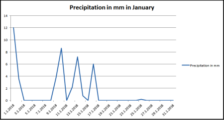
Precipitation data is reversed. Precipitation during January was above average. There were nine rainy days, with 44.4 mm of precipitation, which is 27 % more than the long-term average (35 mm of precipitation). Most precipitation fell on the first day of the year and in the period from 9 to 16 January.
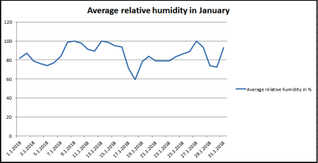
The average relative humidity in January was 85.28 %.
The average monthly temperature was also significantly higher than the average of the period from 1981 to 2010, it was 2.87 °C and it was 2.97 °C higher than the long-term average. The long-term average for January is - 0.1 °C in Maribor.
In January, the average temperature was only four times below the freezing point (0 °C). Only one day the maximum temperature did not exceed 0 °C. The lowest temperature in January was only - 5.32 °C, and the highest temperature was 16.51 °C.
Precipitation data is reversed. Precipitation during January was above average. There were nine rainy days, with 44.4 mm of precipitation, which is 27 % more than the long-term average (35 mm of precipitation). Most precipitation fell on the first day of the year and in the period from 9 to 16 January.
The average relative humidity in January was 85.28 %.
... link (0 Kommentare) ... comment
Meteorological report for Biotechnical School Maribor
beekids, 18:37h
At the school estate, we started observing the weather on 1 January, 2018. The meteorological station is set in the apple orchard in the middle of the school estate. On the southern and eastern side it is closed by blocks of flats, which represent the beginning of the city, and in the north by the hill Kalvarija.
The weather station is type A733 and has a basic set of sensors - sensor for measuring air temperature, relative humidity, precipitation sensor and wetness sensor. From the obtained data we can calculate the average temperature, the highest and the lowest daily temperature, the daily amount of precipitation and the average relative humidity. The data obtained will be compared with the data from the period from 1981 to 2010.
In addition to meteorological data, we will also monitor phenological phases of the plants (fruit trees, pumpkins, potatoes, etc.) and we will also photograph them.
The weather data and phenological phases will also be monitored in Hamburg. Thus, we can compare the development of weather and plants in two completely different locations.
The data will also be presented in graphic form.
We will publish the reports on the blog.
... link (0 Kommentare) ... comment
... nächste Seite